


mosern - brunshkoft

OxygenLT
User
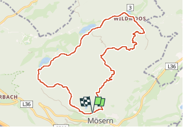

Length
10.8 km

Max alt
1505 m

Uphill gradient
359 m
Km-Effort
15.6 km

Min alt
1243 m

Downhill gradient
372 m
Boucle
Yes
Creation date :
2025-01-27 08:31:47.818
Updated on :
2025-01-27 12:27:14.345
3h54
Difficulty : Medium

FREE GPS app for hiking
 SityTrail
IGN / Geographical institutes
SityTrail Plus
The world is yours!
About
Trail Walking of 10.8 km to be discovered at Tyrol, Bezirk Innsbruck-Land, Marktgemeinde Telfs. This trail is proposed by OxygenLT.
Positioning
Country:
Austria
Region :
Tyrol
Department/Province :
Bezirk Innsbruck-Land
Municipality :
Marktgemeinde Telfs
Location:
Unknown
Start:(Dec)
Start:(UTM)
662211 ; 5242228 (32T) N.
Comments